Colombia is currently staring down the barrel of a violent atmospheric collision. Starting this Wednesday, May 20, 2026, a brutal 48-hour storm system is unleashing extreme electrical activity, infrastructure-rattling winds, and heavy rainfall across the entire country.
Whether you are a North American expat hunkered down in Medellín, a traveler with upcoming flights, or just someone fascinated by extreme weather mechanics, this is a masterclass in atmospheric volatility. The grid is going to take a beating, trees are coming down, and sudden flash floods are imminent.
We are going to break down exactly where this tempest is hitting hardest, the strange science driving this freak weather event, and precisely what you need to do to lock down your gear and ride it out safely.
Colombia Storm Warning: The 48-Hour Danger Zone
This Colombia Storm Warning is not a localized event; it is a massive blanket of instability covering multiple distinct geographical zones. From the high-altitude chill of the Andes to the sweltering Caribbean coast, almost no region is getting a free pass.
The departments facing the highest risk of intense rainfall and severe electrical activity include Santander, Cundinamarca, Boyacá, Antioquia, and the famous Eje Cafetero (Coffee Axis). If you are in these areas, expect the sky to bruise over quickly in the afternoons, followed by torrential downpours.
Here is a quick breakdown of exactly what to expect in key regions over the next 48 hours:
| City / Region | Forecasted 48-Hour Impact |
|---|---|
| Bogotá & High Altitudes | Cold 19°C highs, persistent heavy drizzle, and dense, low-hanging cloud cover. |
| Medellín & Coffee Axis | Spiking humidity leading to sudden, violent afternoon thunderstorms and power flickers. |
| Caribbean Coast (Cartagena) | Sweltering 35°C heat clashing with humidity, triggering isolated but severe wind squalls. |
| Quibdó (Pacific Coast) | Maximum humidity with a near-constant threat of intense, prolonged lightning storms. |
Unpacking the Freak Air Clashes
You might be wondering how a country situated right on the equator suddenly turns into a giant blender of extreme weather. The culprit is a massive, high-speed collision between radically different air masses.
Right now, incredibly dry air currents are slamming head-first into the warm, moisture-heavy air rolling off the oceans and the Amazon basin. This friction acts like a giant atmospheric spark plug.
Here is a wild, hard fact for you: when thermal friction reaches this level of intensity, a single severe tropical storm cell can easily unleash over 6,000 lightning strikes in a single hour.
“When you force bone-dry air into a super-heated, highly humid environment, the atmosphere rapidly destabilizes. It creates towering cumulonimbus clouds that essentially function as massive electrical generators, which is why we are seeing such unprecedented lightning rates.”
Even coastal cities like Barranquilla and Santa Marta, which will remain baking hot, are not safe from this physics lesson. The sheer thermal contrast means a sunny 34-degree afternoon can instantly morph into an isolated storm with roof-tearing wind gusts.
Surviving Record Lightning and Severe Winds
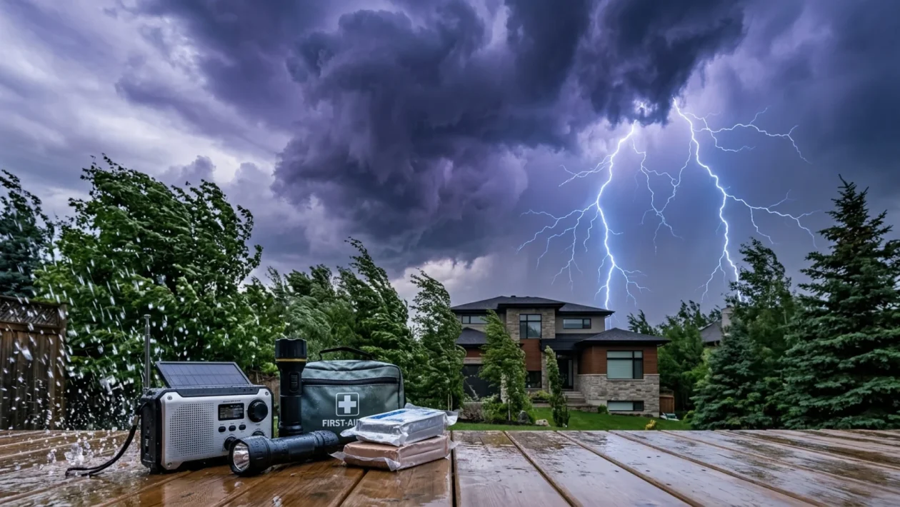
When a storm of this magnitude hits, hoping for the best is a terrible strategy. Infrastructure in many rural and even urban parts of Colombia can be highly vulnerable to sudden wind spikes and grid-frying lightning.
If you are caught in the path of these severe winds and rain, you need to be proactive. Here is how you prepare like a pro:
- Isolate your electronics: Unplug laptops, televisions, and charging phones from the wall. A direct lightning strike to the local grid will easily bypass cheap surge protectors.
- Waterproof the essentials: If you are traveling or living in a flood-prone area, toss your passports, cash, and backup batteries into a reliable MEC dry bag or a heavy-duty Ziploc.
- Secure your perimeter: Walk around your balcony, patio, or yard. Any loose chairs, potted plants, or outdoor gear will become dangerous projectiles when those sudden wind gusts hit.
- Prep for the blackout: Charge all your power banks immediately. Keep a reliable LED headlamp within arm’s reach, and ensure you have enough potable water for at least two days if municipal pumps fail.
FAQs About the 2026 Colombian Super-Storm
Will flights be delayed or cancelled during this window?
Absolutely. With severe lightning and unpredictable wind shear expected around major hubs like Bogotá’s El Dorado and Medellín’s José María Córdova airports, expect rolling delays and ground stops. Always check with your airline before heading to the terminal.
Is it safe to drive between cities right now?
It is highly discouraged. Mountainous routes through Antioquia, Santander, and the Coffee Axis are notorious for sudden landslides and fallen trees during extreme rainfall. If you do not have to be on the road, stay put.
Why is it so cold in Bogotá but boiling on the coast during the same storm?
Colombia’s weather is dictated by elevation, not seasons. Bogotá sits at over 2,600 meters, so heavy cloud cover completely blocks the warming sun, dropping temperatures rapidly. The coast is at sea level, so the trapped humidity just makes the heat feel more oppressive before the rain breaks.
🤝 Stay sharp and respect the weather. Atmospheric clashes of this scale are a powerful reminder of who is really in charge out there.
💡 Prep your gear today, double-check your flight statuses, and don’t take any unnecessary risks on those slick mountain roads.
📱 Share your thoughts in the comments below if you are currently riding out this super-storm in Colombia, and let us know how your local grid is holding up!
👇 Good luck, stay dry, and keep that headlamp fully charged until the skies finally clear.